
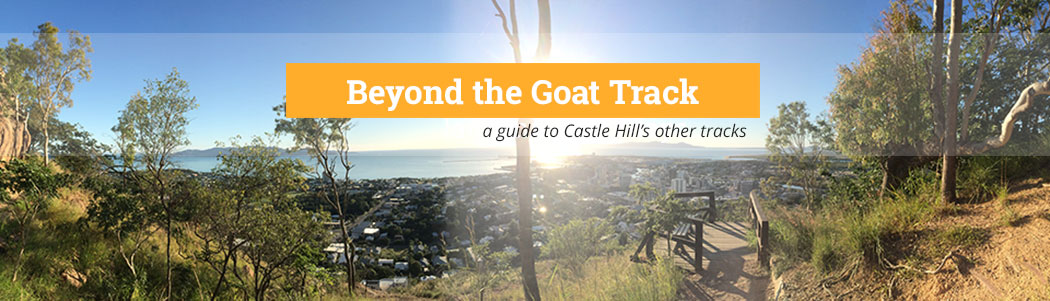
So — hands up — who always does the same Castle Hill tracks? Are you keen to try something different, but have no idea where those twisty trails are going to spit you out? Well, TheGo has a guide and it’s time for you to go exploring…P.S. If you know more tracks that we haven’t included, we would love to hear about them!
- Belgian Gardens Link Track
- Triandra Track
- Dianella to Triandra Link Track
- Westies Track
- Maidenhair Track
- Erythrina to “Scramble Track” Link
- Erythrina Track
- West Ridge Track
- Cudtheringa Track
- The Goat Track
- Ironbark Track
- Dianella Track
- “Scramble” Track
- Widow-maker
- Blue Spot
Cudtheringa Track
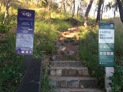
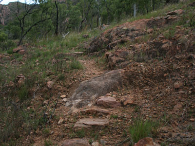
The most popular Castle Hill walking trail, the Cudtheringa Track is accessed from opposite the first car park at the bottom of Castle Hill Road, and spits walkers out just shy of the summit. While the start and end are challenging due to the sharper incline, the mid section is moderate and has stunning views out to the city and Magnetic Island. If you don’t like crowds, avoid it around 5-7pm on weekdays as this track in particular tends to be the choice for post-work workouts. During quieter times, it’s also a fantastic option to practise your trail running.
Starts: Opposite the first car park at the base of Castle Hill Road
Ends: Castle Hill Road, just short of Castle Hill summit
Distance: 1.1km one way
Best bit: The steps at the end — killer.
Puffometer: Puff, puff, puff (the last one is just for those stairs)
Ironbark Track
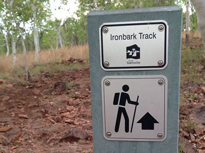
This trail is nice and challenging, but not nearly as populated as the city-side tracks. Starting at James Street in West End (or you can go via the gate at the start of Green Street), it takes you about three quarters of the way up Castle Hill Road. From here, you can reach the top via the bitumen, or continue off-road up the “Scramble Track” (see that section for more info). The Ironbark Track is very rocky and can be a little slippering coming down, but it’s a great heart starter — especially in the beginning as you go up, up, up with little respite. From there it tapers off for about 20m, before it’s up, up, up again (unlike Cudtheringa where there are more flat sections to catch your breath).
Starts: James Street, West End, or around the corner at Green Street, West End
Ends: Castle Hill Road, about three quarters of the way up
Distance: 0.7km one way
Best bit: The bench at the top of the trail for a rest (and some tricep dips).
Puffometer: Puff, puff, puff
Triandra Track

PLEASE NOTE: This track is currently closed while Townsville City Council completes its utilities upgrade. Branching off from the Ironbark track, the Triandra trail links north West End (near Stagpole Street) to the Dianella and Maidenhair Tracks in east West End, near the cemetery. It’s a largely flat trail as it traces the base of the hill, but still has impressive views out to Mount Stuart. Assuming you are heading towards the CBD, there is a brief break in the track at the disused quarry (as you cross over the old quarry road), but you pick the trail straight up at the abandoned concrete structure (which is decorated with Bart Simpson). You will eventually come to a fork in the track — go right, or the ‘low road’. The most challenging part of the track is closer to the West End Cemetery where you need to scramble over a rock face — stay low to the ground and scoot along on your bum if you need to. There is a rocky downhill section after this, but these are really the only tricky bits in an otherwise relatively easy and enjoyable walk.
Starts: A third of the way up the Ironbark Track’s first rocky ascent
Ends: At the intersection of the Dianella and Maidenhair Tracks near the West End Cemetery at the end of Church Street.
Distance: 0.9km one way
Best bit: After heavy rain one of the walls of the quarry turns into a waterfall.
Puffometer: Puff
Dianella to Triandra Link Track
 PLEASE NOTE: This track is currently closed while Townsville City Council completes its utilities upgrade. If you want to avoid the brief rock face scramble that’s in the ‘low road’ section of the Triandra Track, you can turn left in the fork (assuming you are heading towards the CBD). This takes you onto the high road and over relatively easy terrain until you come to the base of the boulder at the Dianella Track. You can go left here and up and over the boulder to eventually reach the summit, or you can bear right and head downhill to either exit the trail at the West End Cemetery on Church Street; or head right onto the Maidenhair Track, which eventually links up with the Goat Track in town.
Starts: At the fork of the Triandra Track
Ends: At the base of a large boulder on the Dianella Track
Distance: 0.22km one way
Best bit: Cuts off the rock face on the ‘low road’ if you are unsteady on your feet.
Puffometer: Puff
Dianella Track
 PLEASE NOTE: This track is currently closed while Townsville City Council completes its utilities upgrade. We think the Dianella Track is one of the most challenging of the Hill’s offering. Starting at the end of Church Street in West End, behind the West End Cemetery, it delivers you near the summit, just a bit further down from the Cudtheringa trail. We think this track one of the most challenging because it is largely straight up with little scope for breath-catching and requires you to climb over a large boulder near the start. Once you are on top of this rock the views are spectacular — drink in Mount Stuart and Cleveland Bay. The top of this rock flattens out nicely so you could almost take a picnic up there to enjoy the ambience. (Plus rumour has it that there are dinosaur footprints in those ancient rocks). There’s a brief downhill section after this, but then it’s straight up the rocky climb to the top. Be careful if you are coming back this way as it can get slippery.
Starts: West End Cemetery at the end of Church Street, West End
Ends: Castle Hill Road, just before the Cudtheringa Track exit
Distance: 0.84km one way
Best bit: The view from the boulder — breathtaking (or is that just the climb to get up there?) 😉
Puffometer: Puff, puff, puff, puff
Maidenhair Track
 This walk is relatively easy as it has few climbs and hugs the base of the hill from West End Cemetery to the Goat Track in town. There are some nice pretty sections, including a bridge over a stream that flows in the wet season; and a little rock pool that’s big enough for the dog to cool off in (again, after it’s rained). It gets a bit more challenging near the Goat Track where a little bit of rock hopping is required.
Starts: West End Cemetery at Church Street, West End
Ends: Near the start of the Goat Track
Distance: 1.13km one way
Best bit: The little rock pool that appears after the rain.
Puffometer: Puff
Maidenhair Lower Track
This easy trail starts just behind the West End Cemetery on Church Street, West End, and offers a pleasant walk parallel to the Maidenhair Track. Although the elevation isn’t high, the view out to Mount Stuart is surprisingly impressive. You will come out on Wilson Street, where there’s a small climb via the road until you’ll re-join the track. Follow a short set of stairs and you’ll eventually come to the Maidenhair Track.
Starts: West End Cemetery at Church Street, West End
Ends: Wilson Street, West End, but rejoins to the Maidenhair Track
Distance: 0.8km one way
Best bit: Fantastic vista with minimal effort.
Puffometer: Puff
The Goat Track
 Starting from Hillside Crescent just outside of the CBD, the best way to describe the Goat Track is short and sharp. Getting to it requires a steep climb up the road, which offers some brief respite once you get to the track, before the incline begins again to take you to a lookout at the intersection of the Cudtheringa Track. The Goat Track is a good way to add a bit of variation if you usually just stick to the Cudtheringa Track and you prefer the city-side tracks.
Starts: Hillside Crescent, Townsville City
Ends: Castle Hill Road, just short of Castle Hill summit
Distance: 0.63km one way
Best bit: Views over the city, Magnetic Island, tip of Pallarenda and around to Cleveland Bay from the lookout.
Puffometer: Puff, puff, puff
Erythrina Track
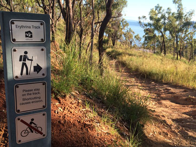 We like to call this one the ‘sneaky shortcut track’ as it allows you to cut a big corner of road off if you are going up or coming down the hill. While this track is short and easy, it’s also very convenient. A lot of walkers know it exists, but many don’t realise that it actually starts from Balmoral Place (off Yarrawonga Drive) in Yarrawonga. Handy to know if you park at the bottom of Jacob’s Ladder, do that challenging climb, turn right onto Yarrawonga Drive, right into Balmoral Place and then onto the Erythrina Trail and the hill.
Starts: Balmoral Place, Yarrawonga
Ends: Castle Hill Road, about half way up
Distance: 0.4km one way
Best bit: Being a sneaky little shortcut if you are running late/lacking energy
Puffometer: Puff
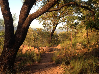
West Ridge Track
 It seems not many people know the existence of this fantastic trail that starts on William Street in West End and finishes half way up the hill, just opposite the end of the Erythrina Track. It has a rocky and relatively steep, but steady, start (watch out if you are coming back this way as it does get slippery and muddy at times), then it flattens out onto the ridgeline where there are stunning views of The Strand and Magnetic Island one way and Mount Stuart the other — 360 degrees of bliss. The track is easier after this, still climbing, but quite gradually, and with the help of stairs in some sections.
Starts: William Street, West End (between Ernest Street and Claude Street)
Ends: Half way up Castle Hill Road, opposite the Erythrina Track
Distance: 1km one way
Best bit: The jaw-dropping 360 degree views
Puffometer: Puff, puff
“Scramble Track”
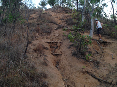 Also known as “Suicide” and “Heartbreak”, this unmarked trail takes you around the back of the summit to join the Radar Hill short walk. With two descent climbs — the last being the most significant — this trail is very steep and challenging (both physically and in terms of the unstable terrain) and is not for the faint-hearted. There are some amazing views when you pause after the first climb that look out to Magnetic Island and back over the suburbs of Townsville, out to the ranges. You will find it opposite the top of the Ironbark Track and it’s a great way to end that walk with a bang. Alternatively, turn left and it eventually connects with the Erythrina Track. (P.S: You may encounter a bike heading downhill on the rare occasion, so keep your eyes and ears open while you’re puffing).
Starts: Opposite the Ironbark Track, about three quarters up Castle Hill Road
Ends: The Radar Hill Walk on the summit
Distance: 0.5km one way
Best bit: The burn, baby!
Puffometer: Puff, puff, puff, puff, puff
Erythrina to “Scramble Track” Link
 Local walkers tell us this trail is also known as “The Ladies’ Track” because it was the inconspicuous route that ‘female friends’ took to visit the soldiers manning the pillboxes on the top of the Hill in WWII. Unsignposted, this trail tends to get overgrown in the wet season, but it is marked with coloured ribbon and blue paint. It stretches from the Erythrina Track to the base of the “Scramble Track”, which is opposite the Ironbark Track. It’s relatively easy with no steep climbs and fantastic views, and is a fantastic way to add variety to your walk if you want to try something different to the road.
Starts: At the Erythrina Track, about half way up Castle Hill Road. It’s opposite the water reservoir with the painted elephants.
Ends: Opposite the Ironbark Track, about three quarters of the way up Castle Hill Road
Distance: 0.6km one way
Best bit: Trying something new, mixing it up and keeping it real…
Puffometer: Puff
The ‘Widow-maker’ Track
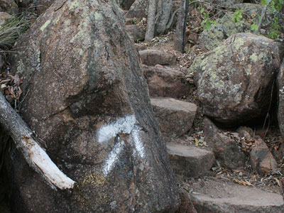
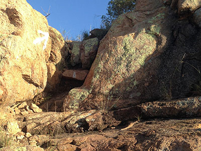
 Another track named by local walkers, the cap certainly fits as this track is spectacular yet a little perilous if you were to lose your footing in some parts (there are no safety barriers). Unmarked, it branches off right from the Goat Track just after the intersection of the Cudtheringa Track, about 3m past the top of the concrete stairs. The path has loose rocks initially, like a riverbed, then moves into steep boulders (pulling up with hands is required in some parts). The views are to die for (pardon the pun) and survey the whole city, Cleveland Bay, the ranges and out to Magnetic Island. The track can be hard to follow in parts, particularly over the rocky sections when it’s sometimes unclear which way to scramble, but it becomes more obvious in the second part as there are nice big white arrows painted. The track eventually spits you out at the end of the Summit Walk at the eastern-most lookout — a great place to catch your breath. While this track is challenging and rewarding, it’s not suitable for pets, children or those with a fear of heights. And we would not recommend going down.
Starts: Goat Track — about 3m after the concrete steps on the last stretch there is an inconspicuous right turn (not signposted).
Ends: Summit Walk lookout
Distance: 0.35km one way
Best bit: Heart-racer – both from the physical exertion and being so elevated and exposed.
Puffometer: Puff, puff, puff, puff
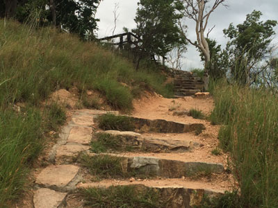
Blue Spot Track
 Given this name by a group of local walkers, this track is certainly not as unassuming as its name. A bit tricky to find the entrance when it’s overgrown, this one starts on the Maidenhair Track, just a bit further east of where the Maidenhair Lower joins the Maidenhair Track (look out for the metal bridge). It finishes near the top of the Dianella Track, where you can access Castle Hill Road. We’d say this trail surpasses the Dianella Track for difficulty — both in a technical and fitness sense — as it’s particularly steep, climbs the whole way and has even more large boulders to climb over. But there are certainly some breathtaking views. Apart from the concealed start, the Blue Spot Track is well-worn and clearly marked with white painted arrows, so there’s little chance of getting lost (just as well as, if you take the wrong turn, you’ll come across a humpy where a hermit resides). We wouldn’t recommend this trail for dogs or young children, and it’s definitely an ‘up’ trail (too dangerous going down).
Starts: On the Maidenhair Track, west of the metal bridge
Ends: Near the top of the Dianella Track
Distance: 0.7km one way
Best bit: The interesting rock formations and the serenity.
Puffometer: Puff, puff, puff, puff, puff (not as steep as the Scramble Track, but consistently challenging).
Belgian Gardens Link Track
This relatively easy track is mostly flat, but has sections of small climbs. It starts on Potts Street (near Belgian Gardens State School, just off the footpath) and can be followed around the back of the school and up to the water reservoir at the end of Grange Court. There are a few rocks, but nothing very technical. If you want to continue to the hill from here, pay attention: Once you’ve just passed the water reservoir turn right. It looks like you are going into the back of some units, but there’s actually a footpath that takes you to Chandon Place. Follow this up to Yarrawonga Drive, turn right, then follow this street until you hit Balmoral Place on the right – this road section is all uphill. The Erythrina Track starts from the end of this cul-de-sac, which takes you to Castle Hill Road. Voila!
Starts: 31 Potts Street, near the back of Belgian Gardens State School. The track veers right from the footpath.
Ends: Off-roadtracks ends at Grange Court, but you can continue to the start of the Erythrina Track via Yarrawonga’s residential streets.
Distance: 1.74km one way.
Best bit: The combination of peaceful off-road scrub with bitumen hills – a good mix.
Puffometer: Puff, puff (due to the hilly bits on the road)
Westies Track (Downhill MTB Track)

You may not notice this track if you didn’t know where to look – on Castle Hill Road, it starts just after the stairs to the Cudtheringa Track, on the left-hand side before the bend. There’s some white paint at the start. This well-maintained trail eventually links to the Scramble Track, opposite the Ironbark Track and has some spectacular views and minor rock scrambles along the way. Just a word of warning if you explore this track: While it’s not an official mountain bike track, downhill mountain bikers built it and do occasionally use it. We advise that you exercise caution at all times if you do decide to walk it (including no earphones or dogs).
Starts: On Castle Hill Road just after the stairs to the Cudtheringa Track, on the left-hand side before the bend.
Ends: Scramble Track (opposite the Ironbark Track)
Distance: 0.8km
Best bit: Being able to choose from a couple of different trail directions within the same route – all ways lead back to the main track.
Puffometer: Puff, puff, puff
Summit Walk, Radar Hill Walk and Pillar Box Walk
These are all short, well-maintained, concreted paths you can do at the top of Castle Hill. They are particularly great for visitors as they afford unrivalled views of Townsville and surrounds and have historical significance, but the Summit Walk is great for those wanting an extra physical challenge. Run that flight of stairs a few times and it will finish you off before your descent.
Round trip ideas for those who don’t like to backtrack…
West End Wonder Walk
Up Ironbark Track > Up Scramble Track (or Castle Hill Road) > Down Castle Hill Road > Down West Ridge Track (short walk to car far from where you started)
The Many Trails Walk
Up Ironbark Track > Across Triandra Track > Across Maidenhair Track > Up Goat Track > Up Cudtheringa Track > Castle Hill Road > Down Scramble Track to Erythrina Link Track > Briefly up Erythrina Track > Down West Ridge Track (short walk to car far from where you started)
City Slicker Walk
Up Goat Track (briefly) > Across Maidenhair Track > Up Dianella Track > Castle Hill Road > Down Cudtheringa Track > Down Goat Track
The Quad Master Walk
Up Dianella Track > Castle Hill Road > Down Ironbark > Across Triandra Track
A note about the Puffometer: This is our own grading in relation to the other tracks on Castle Hill. It has no scientific bearing whatsoever.